Geolocalizar

Mapa topográfico Joida

Mapa interactivo

Haga clic en el mapa para ver la altitud.

Acerca de este mapa

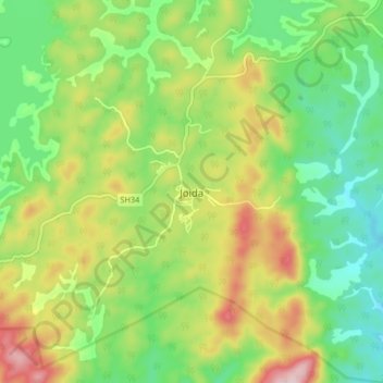
Nombre: Mapa topográfico Joida, altitud, relieve.

Lugar: Joida, Supa taluk, Uttara Kannada, Karnataka, India (15.12375 74.44723 15.20375 74.52723)

Altitud media: 587 m

Altitud mínima: 471 m

Altitud máxima: 769 m

Joida is located at 15°09′38″N 74°28′50″E / 15.160532°N 74.4804383°E / 15.160532; 74.4804383. It has an average elevation of 532 metres (1745.4), and is situated in the Western Ghats. Joida is covered by 87% of dense forest. It is located around 412.1 kilometer away from the state capital Bengaluru and 90 km from district capital Karwar. River Kali begins at a place near Joida called "Kushavali" and the river spread over 162 km in Joida and flows through all four dams (Supa, Bomnalli, Kodasalli and Kadra). Uttarakannada's highest hill called "Terali Betta" is in Joida its 1048 meter tall.