
Mapa topográfico Rizal
Haga clic en el mapa para ver la altitud.
Rizal
The Sinicking National Park has the height of 801 metres (2,628 ft) and the highest elevation between the town's Poblacion and barangay Gaddangao is 1,004 metres (3,294 ft). The entrance to the town is very similar to the Kennon Road of Baguio.
Acerca de este mapa
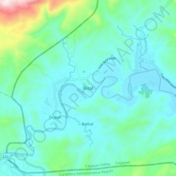
Nombre: Mapa topográfico Rizal, altitud, relieve.
Lugar: Rizal, Cagayan, Cagayan Valley, 3807, Philippines (17.80574 121.30572 17.88574 121.38572)
Altitud media: 154 m
Altitud mínima: 30 m
Altitud máxima: 744 m
Otros mapas topográficos
Haga clic en un mapa para ver su topografía, su altitud y su relieve.