
Mapa topográfico Airway Heights
Mapa interactivo
Haga clic en el mapa para ver la altitud.
Acerca de este mapa
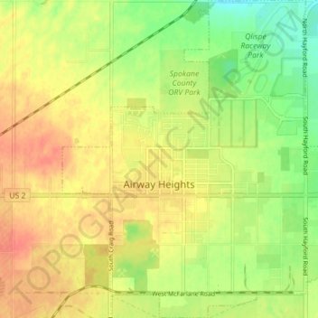
Nombre: Mapa topográfico Airway Heights, altitud, relieve.
Altitud media: 724 m
Altitud mínima: 699 m
Altitud máxima: 743 m
The community lies in the northeastern corner of the flat Columbia Plateau. While the plateau tends to be flat, the terrain locally is quite rugged as it is part of the Channeled Scablands. The "heights" in the city's name references its location at a higher elevation than the city center of Spokane. Traveling into Airway Heights along U.S. 2, the main road into the city, from Downtown Spokane, one will climb over 500 feet.
Otros mapas topográficos
Haga clic en un mapa para ver su topografía, su altitud y su relieve.
Spokane
United States > Washington > Spokane County
Spokane, Spokane County, Washington, United States
Altitud media: 655 m
Newman Lake
United States > Washington > Spokane County
Newman Lake, Spokane County, Washington, 99025, United States
Altitud media: 661 m
Hog Lake
United States > Washington > Spokane County
Hog Lake, Spokane County, Washington, United States
Altitud media: 664 m
Silver Lake
United States > Washington > Spokane County
Silver Lake, Spokane County, Washington, 99022, United States
Altitud media: 741 m
Mead
United States > Washington > Spokane County
Mead, Spokane County, Washington, 99021, United States
Altitud media: 585 m
Country Homes
United States > Washington > Spokane County
Country Homes, Spokane County, Washington, 99251, United States
Altitud media: 599 m
Millwood
United States > Washington > Spokane County
Millwood, Spokane County, Washington, United States
Altitud media: 600 m
Cheney
United States > Washington > Spokane County
Cheney, Spokane County, Washington, United States
Altitud media: 728 m
Deer Park
United States > Washington > Spokane County
Deer Park, Spokane County, Washington, 99006, United States
Altitud media: 658 m
Mount Spokane
United States > Washington > Spokane County
Mount Spokane, Spokane County, Washington, United States
Altitud media: 1,475 m
Liberty Lake
United States > Washington > Spokane County
Liberty Lake, Spokane County, Washington, 99019, United States
Altitud media: 644 m
Spokane Valley
United States > Washington > Spokane County
Spokane Valley, Spokane County, Washington, United States
Altitud media: 673 m
Nine Mile Falls
United States > Washington > Spokane County
Nine Mile Falls, Spokane County, Washington, 99026, United States
Altitud media: 536 m
Riverside State Park
United States > Washington > Spokane County > Spokane
Riverside State Park, Spokane, Spokane County, Washington, United States
Altitud media: 645 m
Medical Lake
United States > Washington > Spokane County
Medical Lake, Spokane County, Washington, 99022, United States
Altitud media: 738 m
Medical Lake
United States > Washington > Spokane County > Medical Lake > Medical Lake
Medical Lake, Spokane County, Washington, 99022, United States
Altitud media: 747 m
Chattaroy
United States > Washington > Spokane County > Chattaroy
Chattaroy, Spokane County, Washington, 99005, United States
Altitud media: 559 m