
Haz una donación
Mapa topográfico Chamundipuram
Haga clic en el mapa para ver la altitud.
Haz una donación
Acerca de este mapa
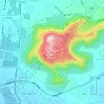
Nombre: Mapa topográfico Chamundipuram, altitud, relieve.
Altitud media: 782 m
Altitud mínima: 704 m
Altitud máxima: 1,058 m
Haz una donación
Otros mapas topográficos
Haga clic en un mapa para ver su topografía, su altitud y su relieve.
Mysuru
India > Karnataka > Mysuru taluk > Mysuru
Mysore is situated at the foothills of the Chamundi Hills. At an altitude of 770 m (2,530 ft) above mean sea level, the city of Mysore is geographically located at 12° 18′ 26″ north latitude and 76° 38′ 59″ east longitude. It is about 140 km (87.0 mi) southwest of the state's capital, Bangalore, and…
Altitud media: 752 m