
Mapa topográfico Emmett
Mapa interactivo
Haga clic en el mapa para ver la altitud.
Acerca de este mapa
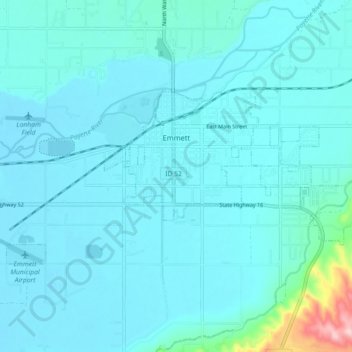
Nombre: Mapa topográfico Emmett, altitud, relieve.
Lugar: Emmett, Gem County, Idaho, United States (43.85026 -116.54272 43.88258 -116.45280)
Altitud media: 738 m
Altitud mínima: 712 m
Altitud máxima: 1,000 m
According to the United States Census Bureau, the city has a total area of 2.82 square miles (7.30 km2), of which 2.80 square miles (7.25 km2) is land and 0.02 square miles (0.05 km2) is water. It is located south of the Payette River, at an elevation of 2,362 feet (720 m) above sea level.
Otros mapas topográficos
Haga clic en un mapa para ver su topografía, su altitud y su relieve.
Sweet
United States > Idaho > Gem County
Sweet, Gem County, Idaho, 83670, United States
Altitud media: 811 m