
Gracias por apoyar a este sitio ❤️
Haz una donación
Haz una donación
Mapa topográfico Timnath
Haga clic en el mapa para ver la altitud.
Gracias por apoyar a este sitio ❤️
Haz una donación
Haz una donación
Acerca de este mapa
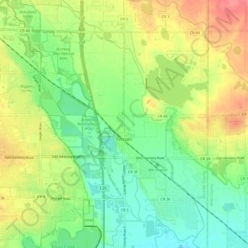
Nombre: Mapa topográfico Timnath, altitud, relieve.
Lugar: Timnath, Larimer County, Colorado, 80547, United States (40.49174 -104.99185 40.57746 -104.94409)
Altitud media: 1,493 m
Altitud mínima: 1,462 m
Altitud máxima: 1,536 m
Gracias por apoyar a este sitio ❤️
Haz una donación
Haz una donación
Otros mapas topográficos
Haga clic en un mapa para ver su topografía, su altitud y su relieve.
Estes Park
United States > Colorado > Larimer County
Estes Park sits at an elevation of 7,522 feet (2,293 m) on the front range of the Rocky Mountains at the eastern entrance of the Rocky Mountain National Park. Its location is 40°22′22″N 105°31′09″W / 40.372856°N 105.519136°W / 40.372856; -105.519136. Its north, south and east extremities…
Altitud media: 2,409 m
Gracias por apoyar a este sitio ❤️
Haz una donación
Haz una donación