
Haz una donación
Mapa topográfico Denholm
Haga clic en el mapa para ver la altitud.
Haz una donación
Denholm
In Main Street, stands The Text House, a category B listed building, erected about 1910 by John Haddon (1845–1924), a medical doctor and author of published works on public sanitation and dietetics. The 3-storey house is in the arts and craft style. One of the texts on the front elevation is a reminder to take care with time before it passes, "TAK TENT IN TIME ~ ERE TIME BE TINT", the other text reminds the occupier that there were and will be others living in the house, "ALL WAS OTHERS ~ ALL WILL BE OTHERS".
Haz una donación
Acerca de este mapa
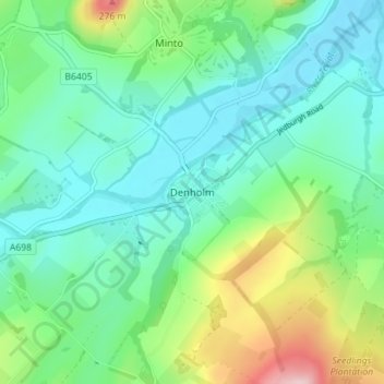
Nombre: Mapa topográfico Denholm, altitud, relieve.
Lugar: Denholm, Scottish Borders, Scotland, TD9 8NU, United Kingdom (55.43804 -2.70362 55.47804 -2.66362)
Altitud media: 128 m
Altitud mínima: 65 m
Altitud máxima: 307 m
Haz una donación
Otros mapas topográficos
Haga clic en un mapa para ver su topografía, su altitud y su relieve.
Haz una donación
Greenknowe Tower
United Kingdom > Scotland > Scottish Borders > Gordon > Nether Huntlywood
Altitud media: 157 m
Haz una donación
Haz una donación
Moffat Hills
United Kingdom > Scotland > Scottish Borders > Tweedsmuir
The Megget Stane (OS. Ref. NT152203) is by a cattle grid at the highest point between the Talla and Megget reservoirs on the minor road which runs from Tweedsmuir on the A701 to Cappercleuch by shore of St Mary's Loch. It is quite easy to miss the stone when coming from Talla as it is hidden by a gate. At an…
Altitud media: 430 m
Curling Pond
United Kingdom > Scotland > Scottish Borders > Earlston > Georgefield
Altitud media: 153 m
Hirsel Lake
United Kingdom > Scotland > Scottish Borders > Coldstream > The Hirsel
Altitud media: 37 m
Haz una donación