
Mapa topográfico Bucharest
Mapa interactivo
Haga clic en el mapa para ver la altitud.
Acerca de este mapa
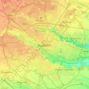
Nombre: Mapa topográfico Bucharest, altitud, relieve.
Lugar: Bucharest, Romania (44.33425 25.96667 44.54140 26.22558)
Altitud media: 82 m
Altitud mínima: 49 m
Altitud máxima: 117 m
The city has an area of 226 km2 (87 sq mi). The altitude varies from 55.8 m (183.1 ft) at the Dâmbovița bridge in Cățelu, southeastern Bucharest and 91.5 m (300.2 ft) at the Militari church. The city has a roughly round shape, with the centre situated in the cross-way of the main north–south/east-west axes at University Square. The milestone for Romania's Kilometre Zero is placed just south of University Square in front of the New St. George Church (Sfântul Gheorghe Nou) at St. George Square (Piața Sfântul Gheorghe). Bucharest's radius, from University Square to the city limits in all directions, varies from 10 to 12 km (6 to 7 mi).
Otros mapas topográficos
Haga clic en un mapa para ver su topografía, su altitud y su relieve.
Dorolea
Dorolea, Livezile, Bistrița-Năsăud, 427122, Romania
Altitud media: 488 m
Carpathian Mountains
Carpathian Mountains, Toplița, Harghita, 535705, Romania
Altitud media: 980 m
Dealul cu Drum
Dealul cu Drum, Greci, Tulcea, 827080, Romania
Altitud media: 168 m