
Haz una donación
Mapa topográfico Gerhardshofen
Haga clic en el mapa para ver la altitud.
Haz una donación
Acerca de este mapa
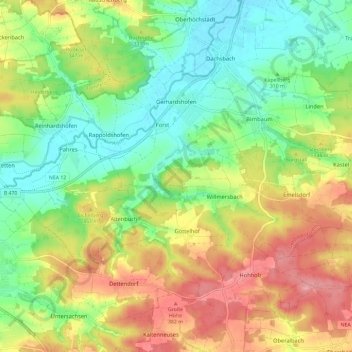
Nombre: Mapa topográfico Gerhardshofen, altitud, relieve.
Altitud media: 329 m
Altitud mínima: 276 m
Altitud máxima: 400 m
Haz una donación
Otros mapas topográficos
Haga clic en un mapa para ver su topografía, su altitud y su relieve.
Rother Berg
Deutschland > Bayern > Landkreis Neustadt an der Aisch-Bad Windsheim > Weigenheim
Altitud media: 371 m
Obernesselbach
Deutschland > Bayern > Landkreis Neustadt an der Aisch-Bad Windsheim > Neustadt an der Aisch
Im Geographischen statistisch-topographischen Lexikon von Franken (1801) wird der Ort folgendermaßen beschrieben.
Altitud media: 347 m
Haz una donación
Sintmannsbuch
Deutschland > Bayern > Landkreis Neustadt an der Aisch-Bad Windsheim > Kästel
Altitud media: 351 m
Altselingsbach
Deutschland > Bayern > Landkreis Neustadt an der Aisch-Bad Windsheim
Altitud media: 385 m
Wulkersdorf
Deutschland > Bayern > Landkreis Neustadt an der Aisch-Bad Windsheim > Emskirchen
Altitud media: 372 m
Altschauerberg
Deutschland > Bayern > Landkreis Neustadt an der Aisch-Bad Windsheim
Das Dorf liegt an einem namenlosen Bach, der ein rechter Zufluss der Mittleren Aurach ist. Der Ort ist im Norden und Osten vom Waldgebiet Hoch und im Süden vom Kalbsholz umgeben. 0,75 km südwestlich liegt die Egertenhöhe (405 m ü. NHN). Eine Gemeindeverbindungsstraße führt nach Neuschauerberg zur…
Altitud media: 379 m
Haz una donación
Birkenfeld
Deutschland > Bayern > Landkreis Neustadt an der Aisch-Bad Windsheim > Neustadt an der Aisch
Altitud media: 320 m
Steinach an der Ens
Deutschland > Bayern > Landkreis Neustadt an der Aisch-Bad Windsheim
Altitud media: 399 m
Haz una donación
Muna-Siedlung
Deutschland > Bayern > Landkreis Neustadt an der Aisch-Bad Windsheim
Altitud media: 446 m
Abteiberg
Deutschland > Bayern > Landkreis Neustadt an der Aisch-Bad Windsheim > Markt Taschendorf
Altitud media: 374 m
Ickelheim
Deutschland > Bayern > Landkreis Neustadt an der Aisch-Bad Windsheim > Bad Windsheim
Altitud media: 335 m
Haz una donación
Neidhardswinden
Deutschland > Bayern > Landkreis Neustadt an der Aisch-Bad Windsheim
Altitud media: 386 m
Pilsenmühle
Deutschland > Bayern > Landkreis Neustadt an der Aisch-Bad Windsheim > Hagenhofen
Altitud media: 393 m
Stübach
Deutschland > Bayern > Landkreis Neustadt an der Aisch-Bad Windsheim
Das Pfarrdorf liegt gegenüber dem Weiler Hanbach am Nordufer und linkem Talhang des unteren Ehebachs, eines linken und zugleich des größten Zuflusses der Aisch, auf Höhen von ca. 285–395 m ü. NHN. Der Altbach zweigt sich etwas oberhalb ab, er fließt an der Straßenbrücke der Kreisstraße NEA 15 wieder…
Altitud media: 329 m
Altmannshausen
Deutschland > Bayern > Landkreis Neustadt an der Aisch-Bad Windsheim > Markt Bibart
Altitud media: 326 m
Haz una donación
Rennersberg
Deutschland > Bayern > Landkreis Neustadt an der Aisch-Bad Windsheim > Ipsheim
Altitud media: 391 m
Oberniederndorf
Deutschland > Bayern > Landkreis Neustadt an der Aisch-Bad Windsheim
Altitud media: 352 m
Haz una donación
Breithart
Deutschland > Bayern > Landkreis Neustadt an der Aisch-Bad Windsheim > Burgbernheim
Altitud media: 438 m
Hirschneuses
Deutschland > Bayern > Landkreis Neustadt an der Aisch-Bad Windsheim
Altitud media: 389 m
Bruckenmühle
Deutschland > Bayern > Landkreis Neustadt an der Aisch-Bad Windsheim > Diespeck
Die Einöde liegt etwa 600 Meter nordwestlich des am rechten Flusstalhang angelegten Kerns des Hauptortes Diespeck am linken Ufer der Aisch, die hier einen kurzen Mühlkanal-Zweig hat. Etwa 350 Meter nordöstlich mündet flussabwärts der Ehebach von Westen her in diese. Jenseits des Ehebachs liegt im…
Altitud media: 313 m
Neuschauerberg
Deutschland > Bayern > Landkreis Neustadt an der Aisch-Bad Windsheim
Altitud media: 376 m
Haz una donación
Hohlweiler
Deutschland > Bayern > Landkreis Neustadt an der Aisch-Bad Windsheim > Scheinfeld
Altitud media: 322 m
Haz una donación
Burg Hoheneck
Deutschland > Bayern > Landkreis Neustadt an der Aisch-Bad Windsheim > Mailheim > Bühlberg
Altitud media: 357 m
Stierhöfstetten
Deutschland > Bayern > Landkreis Neustadt an der Aisch-Bad Windsheim
Altitud media: 370 m
Scheinfeld
Deutschland > Bayern > Landkreis Neustadt an der Aisch-Bad Windsheim > Scheinfeld > Scheinfeld
Altitud media: 345 m
Haz una donación
Uffenheim
Deutschland > Bayern > Landkreis Neustadt an der Aisch-Bad Windsheim > Uffenheim > Uffenheim
Altitud media: 353 m
Eckenhof
Deutschland > Bayern > Landkreis Neustadt an der Aisch-Bad Windsheim > Forst
Altitud media: 304 m
Haz una donación
Unterntief
Deutschland > Bayern > Landkreis Neustadt an der Aisch-Bad Windsheim > Bad Windsheim
Altitud media: 327 m
Fröschendorf
Deutschland > Bayern > Landkreis Neustadt an der Aisch-Bad Windsheim > Merzbach
Altitud media: 384 m
Thierberg
Deutschland > Bayern > Landkreis Neustadt an der Aisch-Bad Windsheim > Scheinfeld
Altitud media: 377 m
Haz una donación
Obersteinbach
Deutschland > Bayern > Landkreis Neustadt an der Aisch-Bad Windsheim
Altitud media: 358 m
Wiebelsheim
Deutschland > Bayern > Landkreis Neustadt an der Aisch-Bad Windsheim > Bad Windsheim
Altitud media: 328 m