
Gracias por apoyar a este sitio ❤️
Haz una donación
Haz una donación
Mapa topográfico Nanjanagudu
Haga clic en el mapa para ver la altitud.
Gracias por apoyar a este sitio ❤️
Haz una donación
Haz una donación
Nanjanagudu
Nanjangud is located at 15°07′N 76°41′E / 15.12°N 76.68°E / 15.12; 76.68. It has an average elevation of 657 metres (2155 ft). The taluk borders Mysore taluk of Mysore district to the north, T Narsipur taluk of Mysore district to the east, H D Kote taluk of Mysore district to the west and Gundlupet and Chamarajanagar taluks of Chamarajanagar district to the south.
Gracias por apoyar a este sitio ❤️
Haz una donación
Haz una donación
Acerca de este mapa
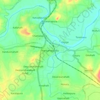
Nombre: Mapa topográfico Nanjanagudu, altitud, relieve.
Altitud media: 667 m
Altitud mínima: 641 m
Altitud máxima: 725 m
Gracias por apoyar a este sitio ❤️
Haz una donación
Haz una donación