
Haz una donación
Mapa topográfico Angat Dam View Deck
Haga clic en el mapa para ver la altitud.
Haz una donación
Acerca de este mapa
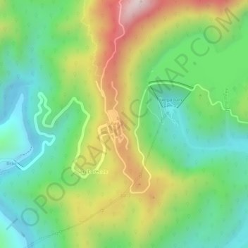
Nombre: Mapa topográfico Angat Dam View Deck, altitud, relieve.
Altitud media: 230 m
Altitud mínima: 59 m
Altitud máxima: 484 m
Haz una donación
Otros mapas topográficos
Haga clic en un mapa para ver su topografía, su altitud y su relieve.
Ipo Dam
Philippines > Bulacan > Norzagaray > Ipo
The spill level of the dam is at an elevation of 101 metres and it has seven radial floodgates. The watershed topography is characterised by mountainous terrain similar to the Angat Reservoir Watershed with moderate forest cover. The watershed has an area of about 70 square kilometers and receives an average…
Altitud media: 174 m
Haz una donación
Ipo Dam
Philippines > Bulacan > Norzagaray > Ipo
The spill level of the dam is at an elevation of 101 metres and it has seven radial floodgates. The watershed topography is characterised by mountainous terrain similar to the Angat Reservoir Watershed with moderate forest cover. The watershed has an area of about 70 square kilometers and receives an average…
Altitud media: 174 m