
Haz una donación
Mapa topográfico Racine County
Haga clic en el mapa para ver la altitud.
Haz una donación
Racine County
Racine County occupies a low, gently varied glacial landscape on the western shore of Lake Michigan, where the terrain descends from subtly rolling inland uplands toward a flatter coastal plain along Racine, Mount Pleasant, Caledonia, and Wind Point. Its relief is modest but clearly organized: the Lake Michigan shoreline forms the lowest local margin, near the lake’s surface elevation, while the western and southwestern parts of the county rise into broader till plains, shallow ridges, and moraine-influenced farmland shaped by the Lake Michigan Lobe of the Wisconsin Glaciation. The county’s physical character is therefore one of subdued but expressive glacial topography, with silty clay and till supporting broad agricultural surfaces, low swales and wetlands in poorly drained areas, and shallow stream corridors such as the Root River and Pike River cutting gently eastward to the lake. Overall, Racine County presents a smooth southeastern Wisconsin terrain of lakeward slopes, soft glacial undulations, and a narrow Great Lakes coastal edge, where urban shorelands, beaches, bluffs, wetlands, and rural uplands form a compact transition between inland moraine country and the open water of Lake Michigan.
Haz una donación
Acerca de este mapa
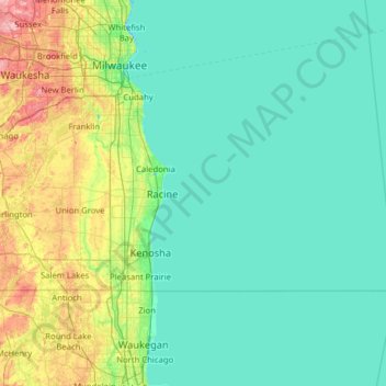
Nombre: Mapa topográfico Racine County, altitud, relieve.
Lugar: Racine County, Wisconsin, United States (42.61086 -88.30725 42.84356 -87.04452)
Altitud media: 198 m
Altitud mínima: 172 m
Altitud máxima: 345 m
Haz una donación
Otros mapas topográficos
Haga clic en un mapa para ver su topografía, su altitud y su relieve.
Wildcat Mountain State Park
United States > Wisconsin > Vernon County > Town of Whitestown
Altitud media: 310 m
Haz una donación
Haz una donación
Milwaukee River Floodplain Forest State Natural Area
United States > Wisconsin > Washington County
Altitud media: 291 m
Haz una donación
Haz una donación
Haz una donación
Haz una donación
Parfrey's Glen State Natural Area
United States > Wisconsin > Sauk County > Town of Merrimac
Altitud media: 360 m
Haz una donación
Haz una donación
Northern Wisconsin State Fairgrounds
United States > Wisconsin > Chippewa County > Chippewa Falls
Altitud media: 279 m
Haz una donación
Haz una donación
Haz una donación
Haz una donación
Haz una donación
Haz una donación
Haz una donación
George W Mead State Wildlife Management Area
United States > Wisconsin > Marathon County > Town of Bergen
Altitud media: 343 m
Haz una donación
Haz una donación
Yellowstone Lake State Park
United States > Wisconsin > Lafayette County > Blanchardville > Town of Fayette
Altitud media: 288 m
Haz una donación
Wildcat Mountain State Park
United States > Wisconsin > Vernon County > Town of Whitestown
Altitud media: 310 m
Haz una donación
Haz una donación
Haz una donación
Marinette County Beech Forest State Natural Area
United States > Wisconsin > Marinette County
Altitud media: 371 m
Haz una donación
Perrot State Park
United States > Wisconsin > Trempealeau County > Town of Trempealeau
Altitud media: 223 m
Haz una donación
Haz una donación
Haz una donación