
Gracias por apoyar a este sitio ❤️
Haz una donación
Haz una donación
Mapa topográfico Eravipuram
Haga clic en el mapa para ver la altitud.
Gracias por apoyar a este sitio ❤️
Haz una donación
Haz una donación
Acerca de este mapa
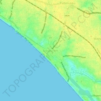
Nombre: Mapa topográfico Eravipuram, altitud, relieve.
Lugar: Eravipuram, Kollam, Kerala, 691011, India (8.83755 76.59744 8.87755 76.63744)
Altitud media: 9 m
Altitud mínima: -1 m
Altitud máxima: 20 m
Gracias por apoyar a este sitio ❤️
Haz una donación
Haz una donación
Otros mapas topográficos
Haga clic en un mapa para ver su topografía, su altitud y su relieve.
Ashtamudi Lake
India > Kerala > Kollam > Kottayathukadavu
Ashtamudi Lake (Ashtamudi Kayal), in the Kollam District of the Indian state of Kerala, is the most visited backwater and lake in the state. It possesses a unique wetland ecosystem and a large palm-shaped (also described as octopus-shaped) water body, second only in size to the Vembanad estuary ecosystem of…
Altitud media: 6 m
Gracias por apoyar a este sitio ❤️
Haz una donación
Haz una donación