
Mapa topográfico Stammbach
Mapa interactivo
Haga clic en el mapa para ver la altitud.
Acerca de este mapa
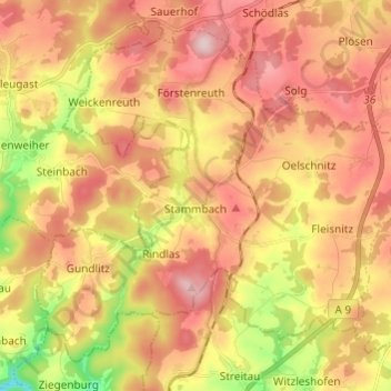
Nombre: Mapa topográfico Stammbach, altitud, relieve.
Lugar: Stammbach, Landkreis Hof, Bayern, Deutschland (50.11525 11.64225 50.18106 11.76335)
Altitud media: 564 m
Altitud mínima: 419 m
Altitud máxima: 669 m
Otros mapas topográficos
Haga clic en un mapa para ver su topografía, su altitud y su relieve.
Köditz
Deutschland > Bayern > Landkreis Hof
Köditz, Landkreis Hof, Bayern, 95189, Deutschland
Altitud media: 543 m
Wurlitz
Deutschland > Bayern > Landkreis Hof > Rehau
Wurlitz, Rehau, Landkreis Hof, Bayern, 95111, Deutschland
Altitud media: 544 m