
Haz una donación
Mapa topográfico Ashton-under-Lyne
Haga clic en el mapa para ver la altitud.
Haz una donación
Ashton-under-Lyne
At 53°29′38″N 2°6′11″W / 53.49389°N 2.10306°W / 53.49389; -2.10306 (53.4941°, −2.1032°), and 160 miles (257 km) north-northwest of London, Ashton-under-Lyne stands on the north bank of the River Tame, about 35 feet (11 m) above the river. Described in Samuel Lewis's A Topographical Dictionary of England (1848) as situated "on a gentle declivity", Ashton-under-Lyne lies on undulating ground by the Pennines, reaching a maximum elevation of about 1,000 feet (305 m) above sea level. It is 6.2 miles (10.0 km) east of Manchester city centre, and is bound on all sides by other towns: Audenshaw, Droylsden, Dukinfield, Mossley, Oldham, and Stalybridge, with little or no green space between them. Ashton experiences a temperate maritime climate, like much of the British Isles.
Haz una donación
Acerca de este mapa
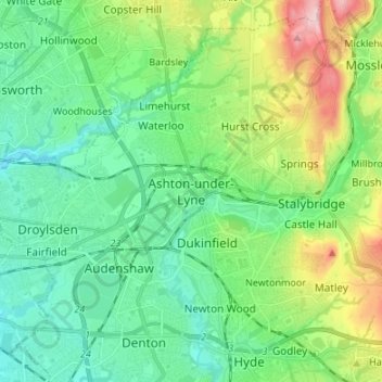
Nombre: Mapa topográfico Ashton-under-Lyne, altitud, relieve.
Altitud media: 129 m
Altitud mínima: 63 m
Altitud máxima: 306 m
Haz una donación
Otros mapas topográficos
Haga clic en un mapa para ver su topografía, su altitud y su relieve.