
Mapa topográfico Yellowstone River
Mapa interactivo
Haga clic en el mapa para ver la altitud.
Acerca de este mapa
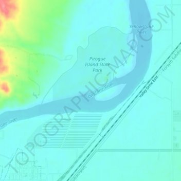
Nombre: Mapa topográfico Yellowstone River, altitud, relieve.
Altitud media: 720 m
Altitud mínima: 707 m
Altitud máxima: 786 m
The Yellowstone River watershed is a river basin spanning 37,167 square miles (96,260 km2) across Montana, with minor extensions into Wyoming and North Dakota, toward headwaters and terminus, respectively. The Yellowstone Basin watershed contains a system of rivers, including the Yellowstone River, and four tributary basins: the Clarks Fork Yellowstone, Wind River and Bighorn River, Tongue River, and Powder River. These rivers form tributaries to the Missouri River. The mainstem of the Yellowstone River is more than 700 miles (1,100 km) long. At the headwaters, elevations exceed 12,800 feet (3,900 m) above sea level and descends to 1,850 feet (560 m) at the confluence with the Missouri River in North Dakota. The watershed spans 34,167 square miles. The area contains many lakes, including Yellowstone Lake. There is no storage dams located on the mainstem of the Yellowstone River. However, the watershed contains five major reservoirs: Bull Lake, Boysen, Buffalo Bill, Big Horn, Tongue River, and Lake De Smet reservoirs.
Otros mapas topográficos
Haga clic en un mapa para ver su topografía, su altitud y su relieve.
Gardiner
United States of America > Montana > Gardiner
Gardiner, Park County, Montana, United States of America
Altitud media: 1,931 m
Belgrade
United States of America > Montana > Belgrade
Belgrade, Gallatin County, Montana, 59714, United States of America
Altitud media: 1,355 m
Waterton-Glacier International Peace Park
United States of America > Montana
Waterton-Glacier International Peace Park, Flathead County, Montana, United States of America
Altitud media: 1,481 m
Snowden
United States of America > Montana > Snowden
Snowden, Roosevelt County, Montana, United States of America
Altitud media: 597 m
Belt Butte
United States of America > Montana
Belt Butte, Cascade County, Montana, United States of America
Altitud media: 1,202 m
McCone County
United States of America > Montana
McCone County, Montana, United States of America
Altitud media: 761 m
West Glacier
United States of America > Montana > West Glacier
West Glacier, Flathead County, Montana, 59936, United States of America
Altitud media: 1,201 m
Creston
United States of America > Montana > Creston
Creston, Flathead County, Montana, 59904, United States of America
Altitud media: 897 m
Mount Vernon
United States of America > Montana
Mount Vernon, Lincoln County, Montana, United States of America
Altitud media: 1,460 m
Saltese
United States of America > Montana > Saltese
Saltese, Mineral County, Montana, United States of America
Altitud media: 1,259 m
Hirsch
United States of America > Montana > Hirsch
Hirsch, Lockwood, Yellowstone County, Montana, United States of America
Altitud media: 959 m