
Mapa topográfico Peermade
Haga clic en el mapa para ver la altitud.
Peermade
The landscape of Peermade includes spectacular waterfalls, open grass lands and pine forests. Predominantly it is classified as Malanad with an elevation ranging from 3,000 ft (910 m) from the mean sea level.
Acerca de este mapa
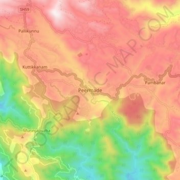
Nombre: Mapa topográfico Peermade, altitud, relieve.
Lugar: Peermade, Peerumade, Idukki, Kerala, 685531, India (9.53201 76.95590 9.61201 77.03590)
Altitud media: 918 m
Altitud mínima: 300 m
Altitud máxima: 1,399 m
Otros mapas topográficos
Haga clic en un mapa para ver su topografía, su altitud y su relieve.
Periyar National Park Tiger Reserve
Periyar National Park lies in the middle of a mountainous area of the Cardamom Hills. In the north : The boundary commences from the point nearest to the Medaganam in the interstate boundary up to Vellimalai. and the east Thence the boundary follows the inter-state boundary from Vellimalai to Kallimalai Peak…
Altitud media: 929 m