
Gracias por apoyar a este sitio ❤️
Haz una donación
Haz una donación
Mapa topográfico Kandukur
Haga clic en el mapa para ver la altitud.
Gracias por apoyar a este sitio ❤️
Haz una donación
Haz una donación
Kandukur
Kandukuru (earlier known as Skandapuri) is located at 15°12′59″N 79°54′15″E / 15.2165°N 79.9042°E / 15.2165; 79.9042. It has an average elevation of 13 metres (43 ft). Kandukur was a part of the erstwhile Nellore district and was then included in the newly carved out Prakasam District in 1970. Later as a part of the district's reorganization in 2022, it is now merged with the residual SPSR Nellore district. The total geographical area of Kandukur Municipality is 37.63 sq km.
Gracias por apoyar a este sitio ❤️
Haz una donación
Haz una donación
Acerca de este mapa
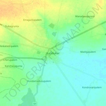
Nombre: Mapa topográfico Kandukur, altitud, relieve.
Altitud media: 18 m
Altitud mínima: 7 m
Altitud máxima: 36 m
Gracias por apoyar a este sitio ❤️
Haz una donación
Haz una donación
Otros mapas topográficos
Haga clic en un mapa para ver su topografía, su altitud y su relieve.