
Mapa topográfico Panabo
Haga clic en el mapa para ver la altitud.
Acerca de este mapa
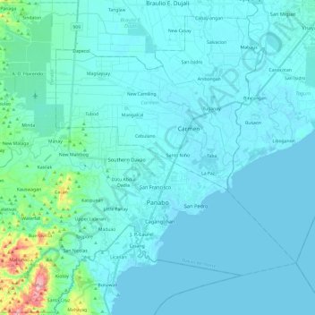
Nombre: Mapa topográfico Panabo, altitud, relieve.
Lugar: Panabo, Davao del Norte, Davao Region, 8105, Philippines (7.22119 125.54644 7.45090 125.73904)
Altitud media: 18 m
Altitud mínima: 0 m
Altitud máxima: 225 m
Otros mapas topográficos
Haga clic en un mapa para ver su topografía, su altitud y su relieve.
Tagum
One of the significant accomplishments of the officialdom of Tagum during the 1990s was its elevation from a second to the first-class municipality. This opened a gateway to increase its financial resources through the Internal Revenue Allocation (IRA) from the national government and local revenues. This was…
Altitud media: 103 m
Pantaron Range
Philippines > Davao del Norte > Kapalong
This article related to topography is a stub. You can help Wikipedia by expanding it.
Altitud media: 409 m