
Mapa topográfico Long Valley Junction
Mapa interactivo
Haga clic en el mapa para ver la altitud.
Acerca de este mapa
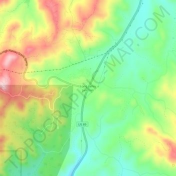
Nombre: Mapa topográfico Long Valley Junction, altitud, relieve.
Altitud media: 2,295 m
Altitud mínima: 2,193 m
Altitud máxima: 2,440 m
Otros mapas topográficos
Haga clic en un mapa para ver su topografía, su altitud y su relieve.
Navajo Lake
United States > Utah > Kane County > Navajo Lake Lodge
Navajo Lake, Navajo Lake Lodge, Kane County, Utah, United States
Altitud media: 2,851 m
Coyote Gulch
United States > Utah > Kane County
Coyote Gulch, Kane County, Utah, United States
Altitud media: 1,361 m
Lone Rock Beach
United States > Utah > Kane County
Lone Rock Beach, Kane County, Utah, United States
Altitud media: 1,134 m
Spooky Gulch
United States > Utah > Kane County
Spooky Gulch, Kane County, Utah, United States
Altitud media: 1,472 m
Cottonwood Point
United States > Utah > Kane County
Cottonwood Point, Kane County, Utah, United States
Altitud media: 1,641 m