
Mapa topográfico Belvidere
Mapa interactivo
Haga clic en el mapa para ver la altitud.
Acerca de este mapa
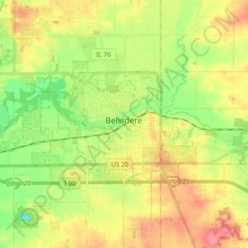
Nombre: Mapa topográfico Belvidere, altitud, relieve.
Altitud media: 244 m
Altitud mínima: 208 m
Altitud máxima: 282 m
Belvidere developed on both sides of the Kishwaukee River in north central Illinois. It is 76 miles from downtown Chicago on Routes 20, 76 and the Northern Illinois Toll road. Belvidere is an industrial community surrounded by prosperous farms. It is the County Seat with an estimated 2006 county population of over 52,000. The altitude is 800 feet above sea level, average temperatures are: 73 degrees F in the summer; 24 degrees F in the winter, and the average rainfall is 33.3 inches, and the average annual snowfall is 35.3 inches.
Otros mapas topográficos
Haga clic en un mapa para ver su topografía, su altitud y su relieve.
Caledonia Township
United States > Illinois > Boone County
Caledonia Township, Boone County, Illinois, United States
Altitud media: 280 m
Poplar Grove Township
United States > Illinois > Boone County
Poplar Grove Township, Boone County, Illinois, 61065, United States
Altitud media: 273 m
Caledonia
United States > Illinois > Boone County
Caledonia, Caledonia Township, Boone County, Illinois, United States
Altitud media: 284 m