
Mapa topográfico Les Ormeaux
Mapa interactivo
Haga clic en el mapa para ver la altitud.
Acerca de este mapa
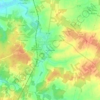
Nombre: Mapa topográfico Les Ormeaux, altitud, relieve.
Altitud media: 55 m
Altitud mínima: 28 m
Altitud máxima: 78 m
Otros mapas topográficos
Haga clic en un mapa para ver su topografía, su altitud y su relieve.
Saint-Hilaire-de-Villefranche
France > Nouvelle-Aquitaine > Charente-Maritime > Saint-Hilaire-de-Villefranche
Saint-Hilaire-de-Villefranche, Saint-Jean-d'Angély, Charente-Maritime, Nouvelle-Aquitaine, France métropolitaine, 17770, France
Altitud media: 55 m
Chez Dyon
France > Nouvelle-Aquitaine > Charente-Maritime > Saint-Hilaire-de-Villefranche
Chez Dyon, Saint-Hilaire-de-Villefranche, Saint-Jean-d'Angély, Charente-Maritime, Nouvelle-Aquitaine, France métropolitaine, 17770, France
Altitud media: 55 m
Chez Chevroux
France > Nouvelle-Aquitaine > Charente-Maritime > Saint-Hilaire-de-Villefranche
Chez Chevroux, La Frédière, Saint-Hilaire-de-Villefranche, Saint-Jean-d'Angély, Charente-Maritime, Nouvelle-Aquitaine, France métropolitaine, 17770, France
Altitud media: 43 m