
Gracias por apoyar a este sitio ❤️
Haz una donación
Haz una donación
Mapa topográfico Mount San Cristobal
Haga clic en el mapa para ver la altitud.
Gracias por apoyar a este sitio ❤️
Haz una donación
Haz una donación
Mount San Cristobal
Mount San Cristobal is a potentially active stratovolcano at the boundary of the provinces of Laguna and Quezon on the island of Luzon, Philippines. The mountain rises to an elevation of 1,470 m (4,820 ft) above mean sea level and is one of the volcanic features of Macolod Corridor.
Gracias por apoyar a este sitio ❤️
Haz una donación
Haz una donación
Acerca de este mapa
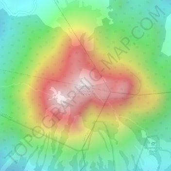
Nombre: Mapa topográfico Mount San Cristobal, altitud, relieve.
Altitud media: 1,021 m
Altitud mínima: 665 m
Altitud máxima: 1,463 m
Gracias por apoyar a este sitio ❤️
Haz una donación
Haz una donación
Otros mapas topográficos
Haga clic en un mapa para ver su topografía, su altitud y su relieve.