
Mapa topográfico Champ de Massé
Mapa interactivo
Haga clic en el mapa para ver la altitud.
Acerca de este mapa
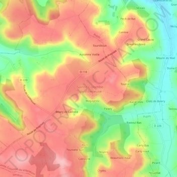
Nombre: Mapa topográfico Champ de Massé, altitud, relieve.
Altitud media: 162 m
Altitud mínima: 79 m
Altitud máxima: 222 m
Otros mapas topográficos
Haga clic en un mapa para ver su topografía, su altitud y su relieve.
Lacroix
France > Nouvelle-Aquitaine > Lot-et-Garonne > Sainte-Colombe-de-Villeneuve > Lacroix
Lacroix, Sainte-Colombe-de-Villeneuve, Villeneuve-sur-Lot, Lot-et-Garonne, Nouvelle-Aquitaine, France métropolitaine, 47300, France
Altitud media: 172 m
Bissières
France > Nouvelle-Aquitaine > Lot-et-Garonne > Sainte-Colombe-de-Villeneuve
Bissières, Sainte-Colombe-de-Villeneuve, Villeneuve-sur-Lot, Lot-et-Garonne, Nouvelle-Aquitaine, France métropolitaine, 47300, France
Altitud media: 161 m