
Mapa topográfico Mount Palanan
Haga clic en el mapa para ver la altitud.
Acerca de este mapa
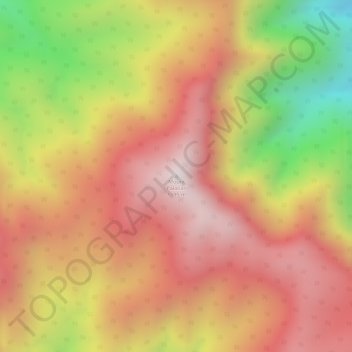
Nombre: Mapa topográfico Mount Palanan, altitud, relieve.
Lugar: Mount Palanan, Cagayan Valley, Philippines (17.06170 122.27554 17.06180 122.27564)
Altitud media: 913 m
Altitud mínima: 446 m
Altitud máxima: 1,192 m
Otros mapas topográficos
Haga clic en un mapa para ver su topografía, su altitud y su relieve.
Batangas
Batangas is a combination of plains and mountains, including one of the world's smallest volcanoes, Mt. Taal, with an elevation of 600 metres (2,000 ft), located in the middle of the Taal Lake. Other important peaks are Mount Macolod with an elevation of 830 metres (2,720 ft), Mt. Banoy with 960 metres (3,150…
Altitud media: 126 m
Laguna
Laguna is home to 24 mountains, most of which are inactive volcanoes. The highest peak in Laguna is Mt. Banahaw, with an elevation of 2,170 m (7,120 ft). Banahaw, unlike most other volcanoes in Laguna, is an active complex stratovolcano, which last erupted in 1843. Banahaw is located in the boundary of Laguna…
Altitud media: 183 m
Metro Manila
The Coastal Margin or Lowland is a flat and low plain that faces Manila Bay. Located here is Manila, Navotas, parts of Malabon, and the western part and reclaimed areas of Pasay and Parañaque, where the ground elevation ranges from zero meters on Manila Bay to five meters at the west side of the cities of…
Altitud media: 43 m
Tarlac
Like the rest of Central Luzon, the province has three distinct seasons: summer from March to June, monsoon rain from July to early October, and monsoon winter from late October to February. Summer months, especially during May bring frequent, sometimes severe, thunderstorms with high winds, thunder, and hail.…
Altitud media: 217 m
Bukidnon
Situated within Bukidnon is Mount Dulang-dulang, the 2nd highest mountain in the country, with an elevation of 2,938 metres (9,639 ft) located in the Kitanglad Mountain Range. Mount Kitanglad (2,899 m), Mount Kalatungan (2,860 m), Mount Maagnaw (2,742 m), Mount Lumuluyaw (2,612 m), and Mount Tuminungan (2,400…
Altitud media: 686 m
Isabela
The province is divided into three physiographic areas. The eastern area, straddled by the Sierra Madre mountain range, is rugged and thickly forested. A substantial portion is uncharted. These unexplored hinterlands are home to a rich variety of flora and fauna, and some are under government reservations. It…
Altitud media: 227 m
Sorsogon
The province has an irregular topography. Except for landlocked Irosin, all the towns lie along the coast. They are all connected by concrete and asphalt roads. Mountain's sprawl over the northeast, southeast and west portions. Mount Bulusan, the tallest peak, rises 1,560 metres (5,120 ft) above sea level.
Altitud media: 51 m
Angeles
Sapangbato is the largest barangay in Angeles in terms of territory, with a total land area of 104,694 sq. meters and a population of 11,262. Located northwest of Angeles near Clark Freeport Zone, it is identified as the barangay in Angeles with the highest elevation of 750 feet above sea level. It is home to…
Altitud media: 98 m
Cagayan de Oro
Cagayan de Oro, located along the north-central coast of Mindanao, Philippines, encompasses a diverse topography that significantly influences its terrain. The city spans approximately 488.86 square kilometers (188.75 square miles), featuring a 25-kilometer (16 miles) coastline along Macajalar Bay. The…
Altitud media: 224 m
Quezon City
In order to make Quezon's dream a reality and to mobilize funds for the land purchase, the People's Homesite Corporation (PHC) was created on October 14, 1938, as a subsidiary of NDC, with an initial capital of ₱2 million. Roces was the chairman of the Board of PHC, and they immediately acquired the vast…
Altitud media: 39 m
Camiguin
Camiguin Island is a pearl-shaped island with an area of approximately 238 km2 (92 sq mi). The island measures about 23 kilometres (14 mi) at its longest and 14.5 kilometres (9.0 mi) at its widest breadth. The island is mountainous with the highest elevation reaching over 5,000 ft (1,500 m). It is encircled by…
Altitud media: 35 m
Masbate
The general surface configuration of the province ranges from slightly undulating to rolling and from hilly to mountainous. In each island, the rugged topography is concentrated in the northeastern portion and gradually recedes to blunt hills and rolling areas in the south, southeast, and southwest.
Altitud media: 28 m
Negros Occidental
Negros Occidental has a tropical climate due to the fact that it is situated close to the equator, being located at least nine degrees north of it. The northern section of the province has a tropical rainforest (Köppen: Af) climate, whereas the southern portion has a tropical monsoon (Köppen: Am) climate.…
Altitud media: 126 m
Cebu
Coal was first discovered in Cebu about 1837. There were 15 localities over the whole island, on both coasts; some desultory mining had been carried out Naga near Mount Uling, but most serious operations were at Licos and Camansi west of Compostela and Danao. Active work ceased about 1895 with insurrections,…
Altitud media: 91 m
Lipa
At the celebration of the elevation of Lipa to a city in January 1888, José Rizal was invited by Dr. Jose Lozada, Catalino Dimayuga and the brothers Celestino and Simeon Luz but Rizal responded only with his Hymno Al Trabajo which he dedicated to the zeal and industry of the Lipeños.
Altitud media: 208 m
Mindanao
In the eastern portion of the island, from Bilas Point in Surigao del Norte to Cape San Agustin in Davao Oriental, is a range of complex mountains known in their northern portion as the Diwata Mountains. This range is low and rolling in its central portion. A proposed road connecting Bislig on the east coast…
Altitud media: 54 m
Laguna de Bay
Laguna de Bay (Spanish for "Lagoon/Lake of Bay"; Tagalog: Lawa ng Bay, [baɪ]), also known as Laguna Lake, is the largest lake in the Philippines. It is located southeast of Metro Manila, between the provinces of Laguna to the south and Rizal to the north. A freshwater lake, it has a surface area of 911–949…
Altitud media: 62 m
Bataan
Bataan is divided by two mountain groups of volcanic origins. The northern side is composed of the Mount Natib (elevation 1,253 metres (4,111 ft)), Mount Sta. Rosa and Mount Silangan. The southern group is composed of Mount Mariveles, Mount Samat, and Mount Cuyapo. A narrow pass separates these two mountain…
Altitud media: 70 m
Palawan
Palawan's almost 2,000 kilometers (1,200 mi) of irregular coastline is lined with rocky coves and sugar-white sandy beaches. It also harbors a vast stretch of virgin forests that carpet its chain of mountain ranges. The mountain heights average 1,100 meters (3,500 ft) in altitude, with the highest peak rising…
Altitud media: 44 m
Cavite
Another theory proposes that the name is a Hispanicized form of kabit, Tagalog for "joined", "connected", or "attached", referring to the peninsula's topographical relation to the mainland. Edmund Roberts, in his 1821 memoir, stated that the "natives" called it Caveit due to the "crooked point of land…
Altitud media: 88 m
Biliran
The main volcanic island of Biliran features mountainous interiors with very narrow coastal areas. Only the municipalities of Naval and Caibiran have wide plains extending about 7 km (4.3 mi) from the coast suitable for agriculture. Mount Suiro, an inactive volcano, is the highest point on Biliran Island with…
Altitud media: 54 m
Benguet
The province suffers from crop damage resulting from seasonal frost during the cold months of December to March, especially in high-altitude towns such as Atok, Buguias, Mankayan and Kibungan. In February 2007, Benguet suffered crop damage due to temperatures reaching as low as 7 °C (45 °F).
Altitud media: 908 m
Magpet
Rice production in Magpet is only 1.16% or 1,028 hectares of the total land area with another 1.50% or 1,115 hectares as potential area due to its land topography, which is mostly hilly or mountainous.
Altitud media: 597 m
Muntinlupa
There are three plausible origins of the name of the city: First, is its association with the thin topsoil in the area; second, residents, purportedly replying to a question by Spaniards in the 16th century what the name of their place was, said “Monte sa Lupa”—apparently mistaking the question for what…
Altitud media: 21 m
Kalinga
Large swaths of the province's lowlands are open grassland suitable for pasture, while the highlands have extensive areas of tropical rainforest. In higher elevations to the west, particularly in the mountains of Balbalan, lie some of the most intact pine forests of Luzon island. Rizal and Tabuk with their…
Altitud media: 667 m
Kidapawan
Located in Kidapawan is the Paniki Falls Eco-River Park located at Umpan Village, Barangay Balabag. Kidapawan is also one of the most well-known starting points for trekking on Mount Apo via the city's Lake Agco in Barangay Ilomavis, Kidapawan-Santa Cruz, and Kidapawan-Magpet trails which towers at 10,311 feet…
Altitud media: 495 m
South Cotabato
Maximum daytime temperature throughout the province is in the range of 36 to 38 °C (97 to 100 °F), falling to 23 to 32 °C (73 to 90 °F) during the night depending on the elevation. The hottest period is January to April while July to December being the coolest.
Altitud media: 418 m
Mindanao
In the eastern portion of the island, from Bilas Point in Surigao del Norte to Cape San Agustin in Davao Oriental, is a range of complex mountains, called the Eastern Pacific Cordillera, known in their northern portion as the Diwata Mountains. This range is low and rolling in its central portion. A proposed…
Altitud media: 149 m
Caraga
Father Saturnino Urios University, was founded by Caraga's most loved Spanish missionary, Fr. Saturnino Urios S.J. in 1990. The Commission on Higher Education (CHED) recognized Father Saturnino Urios University as one of the best schools in the region producing top notchers in national board examinations in…
Altitud media: 136 m
La Trinidad
The terrain is generally mountainous with springs, rivers and creeks. The town has a valley which encompasses several barangays. The valley floor elevation is at 1,300 metres (4,300 ft) above sea level. Elevation ranges from 500 to 1,700 metres (1,600 to 5,600 ft) above sea level.
Altitud media: 1,123 m
Quezon
Rugged terrains characterize the province's topography with few plains, valleys, and swamps. The Sierra Madre Mountain Range runs along the entire length of the area, with Mount Banahaw (an active volcano) rising at 2,169 meters above sea level. Only narrow strips of land along the coast and river valleys are…
Altitud media: 84 m
Northern Mindanao
Northern Mindanao has a total land area of 2,049,602 hectares (5,064,680 acres). More than 60% of Northern Mindanao's total land area are classified as forest land. Its seas abound with fish and other marine products. The abundant vegetation, natural springs and high elevation contribute to the region's cool,…
Altitud media: 356 m
Second Thomas Shoal
On July 12, 2016, the UNCLOS tribunal at the Permanent Court of Arbitration concluded that Second Thomas Shoal is, or in its natural condition was, exposed at low tide and submerged at high tide and, accordingly, has low-tide elevations that do not generate an entitlement to a territorial sea, exclusive…
Altitud media: 0 m
Southern Leyte
Along with other mountain forms in the province, Mount Nacolod in Hinunangan town has the highest peak with an elevation of 948 metres (3,110 ft) above sea level. Young volcanic rocks are discovered in the terrain areas, which cover the top of the southern mountain ranges of Mount Cabalian in the Pacific Area…
Altitud media: 66 m
Aklan
Mount Nausang, is formerly the highest peak in Aklan, standing at 5,190 ft (1,580 m), the discovery of Mount Timbaban is much higher, with an elevation of 5,830.1 ft (1,777.0 m) above sea level, Mount Timbaban is not considered as independent mountain, it is still part of Mount Madja-as sub-summit with only…
Altitud media: 96 m
Siquijor
The island lies about 19 kilometres (12 mi) east of the nearest point on southern Negros, 25 kilometres (16 mi) southeast of Cebu, 30 kilometres (19 mi) southwest of Bohol, and 45 kilometres (28 mi) north of Zamboanga del Norte in Mindanao. It is predominantly hilly and in many places the hills reach the sea,…
Altitud media: 17 m
Ilocos Region
The southern parts of the region were severely hit by the 1990 Luzon earthquake. Five municipalities in La Union were affected: Agoo, Aringay, Caba, Santo Tomas, and Tubao with a combined population of 132,208. Many buildings, including the Agoo Municipal hall, the Museo de Iloko, the parish church of Aringay,…
Altitud media: 219 m
Santa Maria
The topography of Santa Maria is generally flat, however, it is becoming hilly towards the north. This area covers the barangays of Silangan, Mag-asawang Sapa, Pulong Buhangin and some parts of Balasing with landscape ranging from 8 to 18 percent slope. The rest of the barangays have a slope range from level…
Altitud media: 24 m
Basilan
Basilan National Park is at the eastern portion of the remaining public forest between the city of Isabela and the municipalities of Lamitan, Tipo-Tipo and Sumisip. The park has an elevation of 971 metres (3,186 ft) above sea level, and the tallest peak, Puno Mahaji or Basilan Peak, dominates the park's…
Altitud media: 32 m
Dinagat Islands
Dinagat Islands is a young island-province at the northern tip of Mindanao. Many describe Dinagat Islands as a hidden gem of the Caraga Region XIII. The Islands are enriched with great bio-diversity, abundant natural wonders and rich resources. Dinagat Islands has a multitude of fascinating white sandy beaches…
Altitud media: 24 m