
Haz una donación
Mapa topográfico Cotswold District
Haga clic en el mapa para ver la altitud.
Haz una donación
Acerca de este mapa
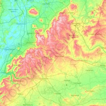
Nombre: Mapa topográfico Cotswold District, altitud, relieve.
Lugar: Cotswold District, Gloucestershire, England, United Kingdom (51.57753 -2.32361 52.11258 -1.61520)
Altitud media: 118 m
Altitud mínima: 6 m
Altitud máxima: 328 m
Haz una donación
Otros mapas topográficos
Haga clic en un mapa para ver su topografía, su altitud y su relieve.
Haz una donación
Jubilee Playing Field & Athletics Track
United Kingdom > England > Gloucestershire > Stroud > Cam > Draycott
Altitud media: 45 m
Duntisbourne Abbots
United Kingdom > England > Gloucestershire > Cotswold District
Altitud media: 204 m
Haz una donación
Haz una donación
Haz una donación
Haz una donación
Highbury
United Kingdom > England > Gloucestershire > Forest of Dean > Lydney > Allaston
Altitud media: 65 m
Haz una donación
Haz una donación
Grange Village
United Kingdom > England > Gloucestershire > Forest of Dean > Littledean
Altitud media: 98 m
Haz una donación
Calcot
United Kingdom > England > Gloucestershire > Cotswold District > Coln Rogers
Altitud media: 151 m
Haz una donación
Haz una donación
Saunders Green
United Kingdom > England > Gloucestershire > Forest of Dean > Whitecroft
Altitud media: 111 m
Bakers Hill
United Kingdom > England > Gloucestershire > Forest of Dean > Broadwell
Altitud media: 195 m
Haz una donación
Haz una donación
Lydney Hub
United Kingdom > England > Gloucestershire > Forest of Dean > Lydney > Allaston > Tutnalls
Altitud media: 42 m
Caudle Green
United Kingdom > England > Gloucestershire > Cotswold District > Brimpsfield
Altitud media: 234 m
Haz una donación
Newent Woods
United Kingdom > England > Gloucestershire > Forest of Dean > May Hill
Altitud media: 157 m
Haz una donación
Haz una donación
Haz una donación
Plump Hill
United Kingdom > England > Gloucestershire > Forest of Dean > Abenhall > Plump Hill
Altitud media: 195 m
Haz una donación
Crumpmeadow Inclosure
United Kingdom > England > Gloucestershire > Forest of Dean > Cinderford
Altitud media: 167 m
Botany Bay Wood
United Kingdom > England > Gloucestershire > Cotswold District > Stow-on-the-Wold
Altitud media: 171 m
Haz una donación
Haz una donación
Lower Berry Hill
United Kingdom > England > Gloucestershire > Forest of Dean > Berry Hill
Altitud media: 193 m
Yorkley Wood
United Kingdom > England > Gloucestershire > Forest of Dean > Pillowell > Yorkley Bottom
Altitud media: 122 m
Haz una donación
Haz una donación
Haz una donación
Little Shurdington
United Kingdom > England > Gloucestershire > Tewkesbury > Bentham
Altitud media: 112 m
Haz una donación
Timbercombe
United Kingdom > England > Gloucestershire > Cheltenham > Charlton Kings
Altitud media: 159 m
Haz una donación
Fossil Beach
United Kingdom > England > Gloucestershire > Forest of Dean > Sedbury
Altitud media: 14 m
Hope Valley
United Kingdom > England > Gloucestershire > Forest of Dean > Lydney > Aylburton
Altitud media: 61 m
Haz una donación