
Mapa topográfico Laidley
Haga clic en el mapa para ver la altitud.
Acerca de este mapa
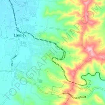
Nombre: Mapa topográfico Laidley, altitud, relieve.
Lugar: Laidley, Lockyer Valley Regional, Queensland, Australia (-27.66059 152.38122 -27.61909 152.44262)
Altitud media: 152 m
Altitud mínima: 94 m
Altitud máxima: 290 m
Otros mapas topográficos
Haga clic en un mapa para ver su topografía, su altitud y su relieve.
Sunshine Coast
Australia > Queensland > Sunshine Coast Regional
The Sunshine Coast in Queensland, Australia, showcases a diverse topography that harmoniously blends coastal plains with rugged hinterlands. Along its eastern edge, the region features expansive sandy beaches and coastal dunes that transition smoothly into fertile lowlands. Inland, the terrain becomes more…
Altitud media: 109 m