
Mapa topográfico Bellefonte
Mapa interactivo
Haga clic en el mapa para ver la altitud.
Acerca de este mapa
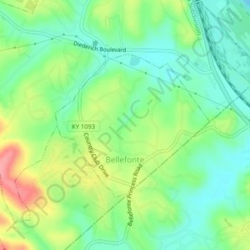
Nombre: Mapa topográfico Bellefonte, altitud, relieve.
Lugar: Bellefonte, Greenup County, Kentucky, United States (38.48856 -82.69979 38.50399 -82.67844)
Altitud media: 188 m
Altitud mínima: 155 m
Altitud máxima: 246 m
The city is located on a one-mile wide belt of relatively flat land that is approximately 100 feet higher in elevation than the nearby Ohio River valley. The unusual topography which is easily noticeable on topographical maps and aerial satellite imagery was created by the ancient Teays River. Larger than the Ohio River, the Teays cut a mile wide valley through the area before being filled with glacial silt during the ice age. This belt of flat land extends from Catlettsburg where it leaves the Ohio River north to near Wurtland and includes parts of Ashland, Westwood, Bellefonte, Russell and Flatwoods. The Ohio River came after the ice age in its current path which created another valley just northeast of Bellefonte. This entire belt of flat land was once known as The Flatwoods beginning in the mid-19th century. The name was retained when it was applied to the nearby city of Flatwoods, just northwest of Bellefonte.
Otros mapas topográficos
Haga clic en un mapa para ver su topografía, su altitud y su relieve.
Flatwoods
United States > Kentucky > Greenup County
Flatwoods, Greenup County, Kentucky, United States
Altitud media: 194 m
Lloyd
United States > Kentucky > Greenup County > Lloyd
Lloyd, Greenup County, Kentucky, 45629, United States
Altitud media: 188 m