
Gracias por apoyar a este sitio ❤️
Haz una donación
Haz una donación
Mapa topográfico Kuttikkanam
Haga clic en el mapa para ver la altitud.
Gracias por apoyar a este sitio ❤️
Haz una donación
Haz una donación
Acerca de este mapa
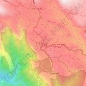
Nombre: Mapa topográfico Kuttikkanam, altitud, relieve.
Lugar: Kuttikkanam, Peerumade, Idukki, Kerala, 685531, India (9.56231 76.95100 9.60231 76.99100)
Altitud media: 943 m
Altitud mínima: 234 m
Altitud máxima: 1,294 m
Gracias por apoyar a este sitio ❤️
Haz una donación
Haz una donación
Otros mapas topográficos
Haga clic en un mapa para ver su topografía, su altitud y su relieve.
Periyar National Park Tiger Reserve
Periyar National Park lies in the middle of a mountainous area of the Cardamom Hills. In the north : The boundary commences from the point nearest to the Medaganam in the interstate boundary up to Vellimalai. and the east Thence the boundary follows the inter-state boundary from Vellimalai to Kallimalai Peak…
Altitud media: 929 m
Gracias por apoyar a este sitio ❤️
Haz una donación
Haz una donación