
Mapa topográfico Kirchehrenbach
Mapa interactivo
Haga clic en el mapa para ver la altitud.
Acerca de este mapa
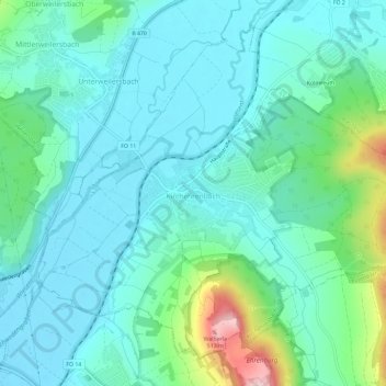
Nombre: Mapa topográfico Kirchehrenbach, altitud, relieve.
Altitud media: 320 m
Altitud mínima: 271 m
Altitud máxima: 516 m
Otros mapas topográficos
Haga clic en un mapa para ver su topografía, su altitud y su relieve.
Forchheim
Deutschland > Bayern > Landkreis Forchheim
Forchheim, Landkreis Forchheim, Bayern, 91301, Deutschland
Altitud media: 299 m
St. Walpurgis
Deutschland > Bayern > Landkreis Forchheim > Kirchehrenbach
St. Walpurgis, Kirchehrenbach, Kirchehrenbach (VGem), Landkreis Forchheim, Bayern, 91356, Deutschland
Altitud media: 347 m
Hallerndorf
Deutschland > Bayern > Landkreis Forchheim
Hallerndorf, Landkreis Forchheim, Bayern, 91352, Deutschland
Altitud media: 295 m