
Mapa topográfico Austinville
Mapa interactivo
Haga clic en el mapa para ver la altitud.
Acerca de este mapa
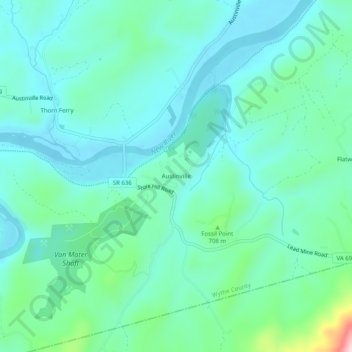
Nombre: Mapa topográfico Austinville, altitud, relieve.
Lugar: Austinville, Wythe County, Virginia, 24312, United States (36.83123 -80.93202 36.87123 -80.89202)
Altitud media: 645 m
Altitud mínima: 585 m
Altitud máxima: 896 m
Otros mapas topográficos
Haga clic en un mapa para ver su topografía, su altitud y su relieve.
Ivanhoe
United States > Virginia > Wythe County
Ivanhoe, Wythe County, Virginia, 24350, United States
Altitud media: 643 m
Cripple Creek
United States > Virginia > Wythe County > Speedwell
Cripple Creek, Speedwell, Wythe County, Virginia, 24374, United States
Altitud media: 733 m
Wytheville
United States > Virginia > Wythe County
Wytheville, Wythe County, Virginia, 24382, United States
Altitud media: 720 m
Barren Springs
United States > Virginia > Wythe County
Barren Springs, Wythe County, Virginia, 24313, United States
Altitud media: 642 m
Max Meadows
United States > Virginia > Wythe County
Max Meadows, Wythe County, Virginia, United States
Altitud media: 662 m
Stones Mill
United States > Virginia > Wythe County > Wytheville > Stones Mill
Stones Mill, Wytheville, Wythe County, Virginia, 24382, United States
Altitud media: 710 m