
Haz una donación
Mapa topográfico Ashby St. Mary
Haga clic en el mapa para ver la altitud.
Haz una donación
Ashby St. Mary
Ashby's topography is, like most of East Anglia, made up of river meadows and flat agricultural landscape. The geology mostly consists of Cainozoic Sedimentary rock, with a layer of boulder clay and sand laid down in the last ice age. Ashby St Mary has slightly acidic loamy and clayey soils with impeded drainage, and low carbon. The cropping of Ashby is reasonably flexible but more suited to autumn sown crops and grassland.
Haz una donación
Acerca de este mapa
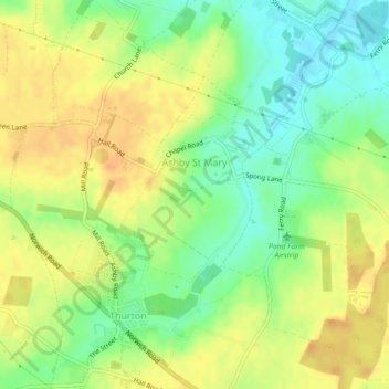
Nombre: Mapa topográfico Ashby St. Mary, altitud, relieve.
Lugar: Ashby St. Mary, South Norfolk, Norfolk, England, United Kingdom (52.55960 1.42062 52.57195 1.45185)
Altitud media: 20 m
Altitud mínima: 0 m
Altitud máxima: 36 m
Haz una donación
Otros mapas topográficos
Haga clic en un mapa para ver su topografía, su altitud y su relieve.
Poringland Wood
United Kingdom > England > Norfolk > South Norfolk > Framingham Earl
Altitud media: 50 m
Haz una donación
Fundenhall
United Kingdom > England > Norfolk > South Norfolk > Ashwellthorpe and Fundenhall
Altitud media: 50 m
Haz una donación
Haz una donación
Haz una donación
Beckhithe
United Kingdom > England > Norfolk > South Norfolk > Little Melton > Beckhithe
Altitud media: 37 m
Haz una donación
Haz una donación
Haz una donación