
Gracias por apoyar a este sitio ❤️
Haz una donación
Haz una donación
Mapa topográfico Palestine
Haga clic en el mapa para ver la altitud.
Gracias por apoyar a este sitio ❤️
Haz una donación
Haz una donación
Palestine
About 40% of the content from the 2003 Space Shuttle Columbia disaster was recovered, seven astronauts were killed in the accident. Debris from Columbia was found in and outside Palestine and other East Texas towns. Palestine's NASA Columbia Scientific Balloon Facility (renamed in honor of the shuttle crew), has flown 1,700 high-altitude balloons for universities and research agencies.
Gracias por apoyar a este sitio ❤️
Haz una donación
Haz una donación
Acerca de este mapa
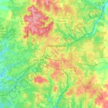
Nombre: Mapa topográfico Palestine, altitud, relieve.
Lugar: Palestine, Anderson County, Texas, United States (31.69527 -95.72426 31.80843 -95.56776)
Altitud media: 136 m
Altitud mínima: 85 m
Altitud máxima: 204 m
Gracias por apoyar a este sitio ❤️
Haz una donación
Haz una donación
Otros mapas topográficos
Haga clic en un mapa para ver su topografía, su altitud y su relieve.