
Haz una donación
Mapa topográfico Groveland
Haga clic en el mapa para ver la altitud.
Haz una donación
Groveland
Groveland is a census-designated place (CDP) in Tuolumne County, California. Groveland sits at an elevation of 3,136 feet (956 m). The 2020 United States census reported Groveland's population was 540.
Haz una donación
Acerca de este mapa
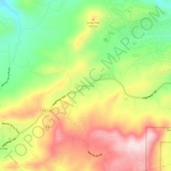
Nombre: Mapa topográfico Groveland, altitud, relieve.
Altitud media: 898 m
Altitud mínima: 706 m
Altitud máxima: 1,097 m
Haz una donación
Otros mapas topográficos
Haga clic en un mapa para ver su topografía, su altitud y su relieve.
Sonora
United States > California > Tuolumne County
Sonora is located around the intersection of California State Highways 49 and 108 The altitude is 1,825 feet (556 m). According to the United States Census Bureau, the city covers a total area of 3.2 square miles (8.3 km2), making it the county's largest community by land area. 99.57% of the area is land and…
Altitud media: 614 m
Sonora
United States > California > Tuolumne County
Sonora is located at 37°59′04″N 120°22′54″W / 37.984361°N 120.381767°W / 37.984361; -120.381767, around the intersection of California State Highways 49 and 108 The altitude is 1,825 feet (556 m). According to the United States Census Bureau, the city has a total area of 3.1 square miles…
Altitud media: 615 m
Twain Harte
United States > California > Tuolumne County
Twain Harte is situated in Tuolumne County along Highway 108 at an elevation of 3,640 feet (1,110 m).
Altitud media: 1,123 m
Haz una donación
Haz una donación
Haz una donación
Tuolumne Meadows
United States > California > Tuolumne County > Tuolumne Meadows
Altitud media: 2,668 m
Haz una donación
Sonora
United States > California > Tuolumne County
Sonora is located at 37°59′04″N 120°22′54″W / 37.984361°N 120.381767°W / 37.984361; -120.381767, around the intersection of California State Highways 49 and 108 The altitude is 1,825 feet (556 m). According to the United States Census Bureau, the city has a total area of 3.1 square miles…
Altitud media: 615 m
Haz una donación
Columbia
United States > California > Tuolumne County
Columbia is located along State Route 49 just north of Sonora, at an altitude of 2,139 feet (652 m).
Altitud media: 672 m
Haz una donación