
Mapa topográfico Plech
Mapa interactivo
Haga clic en el mapa para ver la altitud.
Acerca de este mapa
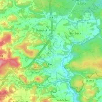
Nombre: Mapa topográfico Plech, altitud, relieve.
Altitud media: 475 m
Altitud mínima: 426 m
Altitud máxima: 567 m
Otros mapas topográficos
Haga clic en un mapa para ver su topografía, su altitud y su relieve.
Fichtelberg
Germany > Bavaria > Landkreis Bayreuth
Fichtelberg, Landkreis Bayreuth, Bavaria, 95686, Germany
Altitud media: 697 m
Gottelhof
Germany > Bavaria > Landkreis Bayreuth > Hollfeld
Gottelhof, Hollfeld, Hollfeld (VGem), Landkreis Bayreuth, Bavaria, 95515, Germany
Altitud media: 407 m
Röhrig
Germany > Bavaria > Landkreis Bayreuth > Bindlacher Berg
Röhrig, Bindlacher Berg, Bindlach, Landkreis Bayreuth, Bavaria, 95463, Germany
Altitud media: 410 m
Gefrees
Germany > Bavaria > Landkreis Bayreuth
Gefrees, Landkreis Bayreuth, Bavaria, 95482, Germany
Altitud media: 585 m