
Haz una donación
Mapa topográfico Argonne
Haga clic en el mapa para ver la altitud.
Haz una donación
Argonne
The Forest of Argonne (French pronunciation: [aʁɡɔn] ) is a long strip of mountainous and wild woodland in northeastern France, approximately 200 km (120 mi) east of Paris. The forest measures roughly 65 km (40 mi) long and 15 km (9 mi) wide filled with many small hills and deep valleys formed by water run-off from the Aire and Aisne rivers rarely exceeding more than 200 m (650 ft) in elevation. Following the First World War, the landscape of the forest was forever changed as trench warfare led to parts of the forest being riddled with deep human-made trenches along with craters from explosives. The forest is bordered by the Meuse River on the west and rolling farmland and creeks to the east. The forest is largely oak, chestnut, and pine trees, and ferns cover much of the forest floor. Common animal life consists of wild boar, red deer, roe deer, hares, rabbits, foxes, and wildcat.
Haz una donación
Acerca de este mapa
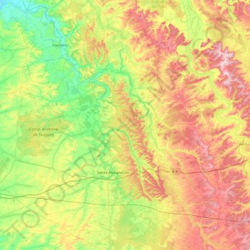
Nombre: Mapa topográfico Argonne, altitud, relieve.
Lugar: Argonne, Marne, Grand Est, Metropolitan France, France (48.90189 4.66237 49.50579 5.20653)
Altitud media: 197 m
Altitud mínima: 76 m
Altitud máxima: 388 m
Haz una donación
Otros mapas topográficos
Haga clic en un mapa para ver su topografía, su altitud y su relieve.