
Mapa topográfico Illmensee
Mapa interactivo
Haga clic en el mapa para ver la altitud.
Illmensee
The municipality (Gemeinde) of Illmensee is situated at the southeastern corner of the district of Sigmaringen, in the German state of Baden-Württemberg. Illmensee lies along Sigmaringen's border with the district of Ravensburg to the east and the Bodensee district to the south. The municipality is physically located in a depression formed by the Würm glaciation in the Upper Swabian hill country [de]. The municipality's three lakes, the Illmensee itself, Ruschweiler [de], and the Volzer [de] lakes, are glacial lakes that were also formed by the Würm glaciation. Elevation above sea level in the municipal area ranges from a high of 833 meters (2,733 ft) Normalnull (NN) to a low of 667 meters (2,188 ft) NN.
Acerca de este mapa
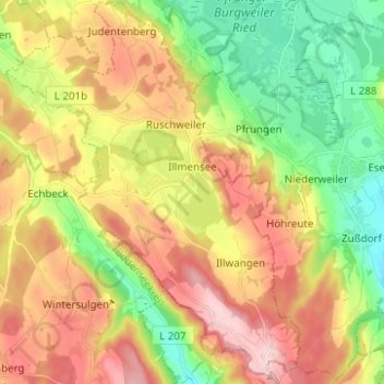
Nombre: Mapa topográfico Illmensee, altitud, relieve.
Altitud media: 698 m
Altitud mínima: 577 m
Altitud máxima: 839 m
Otros mapas topográficos
Haga clic en un mapa para ver su topografía, su altitud y su relieve.