
Gracias por apoyar a este sitio ❤️
Haz una donación
Haz una donación
Mapa topográfico La Ville
Haga clic en el mapa para ver la altitud.
Gracias por apoyar a este sitio ❤️
Haz una donación
Haz una donación
Acerca de este mapa
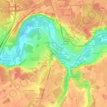
Nombre: Mapa topográfico La Ville, altitud, relieve.
Altitud media: 78 m
Altitud mínima: 46 m
Altitud máxima: 97 m
Gracias por apoyar a este sitio ❤️
Haz una donación
Haz una donación
Otros mapas topográficos
Haga clic en un mapa para ver su topografía, su altitud y su relieve.
Château d'Artigny
France > Centre-Val de Loire > Indre-et-Loire > Montbazon > Moulin de la Braye
Altitud media: 76 m