
Mapa topográfico Mullingar
Haga clic en el mapa para ver la altitud.
Acerca de este mapa
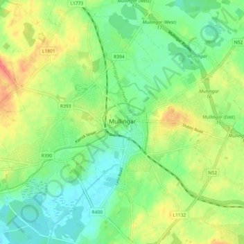
Nombre: Mapa topográfico Mullingar, altitud, relieve.
Altitud media: 99 m
Altitud mínima: 79 m
Altitud máxima: 126 m
Otros mapas topográficos
Haga clic en un mapa para ver su topografía, su altitud y su relieve.
Lough Lene
The lake is described in Samuel Lewis's Topographical Dictionary of Ireland (1837) as being an irregular oval shape, possibly 3.2 km (2.0 mi) long by 1.7 km (1.1 mi) broad. A fresh water lake, most sources focus on the clarity of the water, with the term "gin clear" being used to describe it. It sits…
Altitud media: 109 m