
Mapa topográfico Ocean City
Mapa interactivo
Haga clic en el mapa para ver la altitud.
Acerca de este mapa
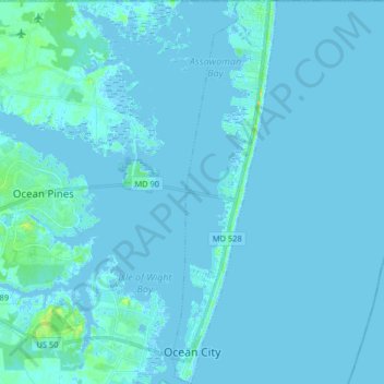
Nombre: Mapa topográfico Ocean City, altitud, relieve.
Lugar: Ocean City, Worcester County, Maryland, United States (38.32409 -75.09345 38.45126 -75.04913)
Altitud media: 1 m
Altitud mínima: -5 m
Altitud máxima: 19 m
Otros mapas topográficos
Haga clic en un mapa para ver su topografía, su altitud y su relieve.
West Ocean City
United States > Maryland > Worcester County > West Ocean City
West Ocean City, Worcester County, Maryland, United States
Altitud media: 2 m
Stockton
United States > Maryland > Worcester County > Stockton
Stockton, Worcester County, Maryland, United States
Altitud media: 8 m
Snow Hill
United States > Maryland > Worcester County
Snow Hill, Worcester County, Maryland, United States
Altitud media: 7 m
Ocean Pines
United States > Maryland > Worcester County
Ocean Pines, Worcester County, Maryland, United States
Altitud media: 3 m
Assateague Island National Seashore
United States > Maryland > Worcester County > West Ocean City
Assateague Island National Seashore, West Ocean City, Worcester County, Maryland, United States
Altitud media: 2 m
Newark
United States > Maryland > Worcester County > Newark
Newark, Worcester County, Maryland, United States
Altitud media: 10 m
Worcester County
United States > Maryland > Worcester County
Worcester County, Maryland, United States
Altitud media: 6 m