
Gracias por apoyar a este sitio ❤️
Haz una donación
Haz una donación
Mapa topográfico Hidden Lake
Haga clic en el mapa para ver la altitud.
Gracias por apoyar a este sitio ❤️
Haz una donación
Haz una donación
Acerca de este mapa
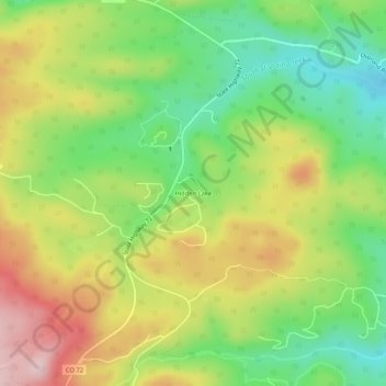
Nombre: Mapa topográfico Hidden Lake, altitud, relieve.
Lugar: Hidden Lake, Boulder County, Colorado, United States (40.08999 -105.49861 40.12999 -105.45861)
Altitud media: 2,679 m
Altitud mínima: 2,556 m
Altitud máxima: 2,833 m
Gracias por apoyar a este sitio ❤️
Haz una donación
Haz una donación
Otros mapas topográficos
Haga clic en un mapa para ver su topografía, su altitud y su relieve.
Nederland
United States > Colorado > Boulder County
In 1873 the Caribou Mine, at an elevation of roughly 10,000 feet (3,000 m) and 6 miles (10 km) northwest of the town, was sold to the Mining Company Nederland from the Netherlands. The high elevation meant fierce winds and deep winter snow, so the new owners of the mine decided that it was beneficial to bring…
Altitud media: 2,578 m
Gracias por apoyar a este sitio ❤️
Haz una donación
Haz una donación