
Haz una donación
Mapa topográfico Richmond County
Haga clic en el mapa para ver la altitud.
Haz una donación
Richmond County
The highest point on the island, the summit of Todt Hill, elevation 401 ft (122 m), is also the highest point in the five boroughs, as well as the highest point on the Atlantic coastal plain south of Great Blue Hill in Massachusetts and the highest point on the coast proper south of Maine's Camden Hills. Ward's Point in the neighborhood of Tottenville is the southernmost point in the state of New York.
Haz una donación
Acerca de este mapa
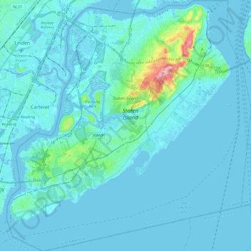
Nombre: Mapa topográfico Richmond County, altitud, relieve.
Lugar: Richmond County, New York, United States (40.47658 -74.25884 40.65151 -74.03461)
Altitud media: 9 m
Altitud mínima: -5 m
Altitud máxima: 121 m
Haz una donación
Otros mapas topográficos
Haga clic en un mapa para ver su topografía, su altitud y su relieve.
Haz una donación
Flushing Meadows-Corona Park
United States > New York > New York
Around 1907, contractor Michael Degnon, whose firm constructed the Williamsburg Bridge, the Cape Cod Canal, and the Steinway subway tunnel (used by today's 7 and <7> trains), purchased large tracts of marsh near Flushing Creek. At the time, the land was considered "all but worthless". Degnon envisioned…
Altitud media: 15 m
Haz una donación
Haz una donación
Haz una donación
Haz una donación