
Mapa topográfico Mount Elbert
Mapa interactivo
Haga clic en el mapa para ver la altitud.
Acerca de este mapa
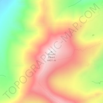
Nombre: Mapa topográfico Mount Elbert, altitud, relieve.
Lugar: Mount Elbert, Lake County, Colorado, United States (39.11793 -106.44510 39.11803 -106.44500)
Altitud media: 3,958 m
Altitud mínima: 3,421 m
Altitud máxima: 4,394 m
The summit of Mount Elbert at 14,440 feet (4401.2 m) elevation is the highest summit of the Rocky Mountains of North America, the highest point in the U.S. State of Colorado, and the second-highest summit in the contiguous United States after Mount Whitney. The ultra-prominent fourteener is the highest peak in the Sawatch Range, as well as the highest point in the entire Mississippi River drainage basin. Mount Elbert is located in San Isabel National Forest, 12.1 miles (19.4 km) southwest (bearing 223°) of the City of Leadville in Lake County, Colorado.
Otros mapas topográficos
Haga clic en un mapa para ver su topografía, su altitud y su relieve.
Mount Sherman
United States > Colorado > Lake County
Mount Sherman, Lake County, Colorado, United States
Altitud media: 3,989 m
Leadville
United States > Colorado > Lake County
Leadville, Lake County, Colorado, 80461, United States
Altitud media: 3,106 m
Leadville
United States > Colorado > Lake County
Leadville, Lake County, Colorado, 80461, United States
Altitud media: 3,106 m
Lake County
United States > Colorado > Lake County
Lake County, Colorado, United States
Altitud media: 3,398 m