
Mapa topográfico Lac Graveirette
Mapa interactivo
Haga clic en el mapa para ver la altitud.
Acerca de este mapa
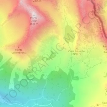
Nombre: Mapa topográfico Lac Graveirette, altitud, relieve.
Altitud media: 2,330 m
Altitud mínima: 1,831 m
Altitud máxima: 2,861 m
Otros mapas topográficos
Haga clic en un mapa para ver su topografía, su altitud y su relieve.
Col Ferrière
France > Provence-Alpes-Côte d'Azur > Valdeblore
Col Ferrière, Route des Millefonts, Saint-Dalmas, Valdeblore, Nice, Alpes-Maritimes, Provence-Alpes-Côte d'Azur, France métropolitaine, 06420, France
Altitud media: 2,312 m
Lac d'en Veillos
France > Provence-Alpes-Côte d'Azur > Valdeblore
Lac d'en Veillos, Route des Millefonts, Saint-Dalmas, Valdeblore, Nice, Alpes-Maritimes, Provence-Alpes-Côte d'Azur, France métropolitaine, 06420, France
Altitud media: 2,315 m
Lacs du Clot Barrat
France > Provence-Alpes-Côte d'Azur > Valdeblore
Lacs du Clot Barrat, Route des Millefonts, Saint-Dalmas, Valdeblore, Nice, Alpes-Maritimes, Provence-Alpes-Côte d'Azur, France métropolitaine, 06420, France
Altitud media: 2,310 m