
Haz una donación
Mapa topográfico New Halabja
Haga clic en el mapa para ver la altitud.
Haz una donación
Acerca de este mapa
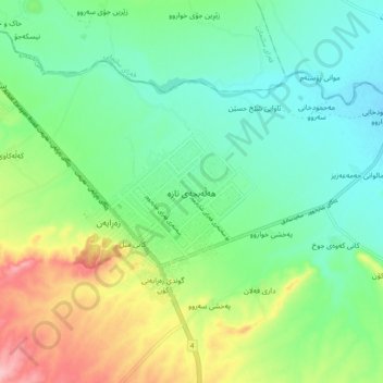
Nombre: Mapa topográfico New Halabja, altitud, relieve.
Altitud media: 549 m
Altitud mínima: 504 m
Altitud máxima: 647 m
Haz una donación
Otros mapas topográficos
Haga clic en un mapa para ver su topografía, su altitud y su relieve.
Darbandikhan Dam
Iraq > Sulaymaniyah Governorate > Darbandikhan
The dam is located within a gorge on a foundation of sedimentary rocks. It is a rock-fill embankment type with a central clay core. The dam is 128 m (420 ft) tall and 445 m (1,460 ft) long (535 m (1,755 ft) if the spillway section is included). Its crest is 17 m (56 ft) wide and at an elevation of 495 m (1,624…
Altitud media: 571 m
Haz una donación
Haz una donación
Haz una donación
Haz una donación
Haz una donación
Haz una donación
Haz una donación