
Haz una donación
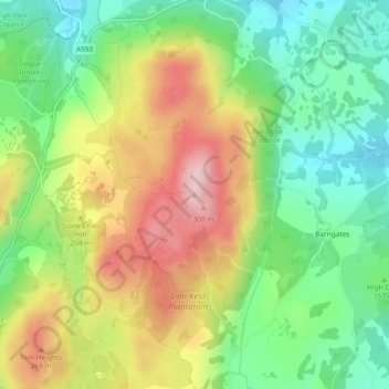
Mapa topográfico Black Fell
Haga clic en el mapa para ver la altitud.
Haz una donación
Black Fell
Black Fell is the high point in the hilly area bounded by Windermere, Langdale and Coniston. It occupies an area of around one mile by two, clad mainly in fell grass with many small outcrops of rock. Despite its modest altitude Alfred Wainwright accorded Black Fell a chapter in his Pictorial Guide to the Lakeland Fells, partly due to its excellence as a view point. It represents the perimeter of the Lakeland Fells proper in his opinion, the land to the south falling within his supplementary volume, The Outlying Fells of Lakeland. Later guidebook writers have also included Black Fell within their remit.
Haz una donación
Acerca de este mapa
Nombre: Mapa topográfico Black Fell, altitud, relieve.
Altitud media: 170 m
Altitud mínima: 60 m
Altitud máxima: 320 m
Haz una donación
Otros mapas topográficos
Haga clic en un mapa para ver su topografía, su altitud y su relieve.
Wharton Tarn
United Kingdom > England > Westmorland and Furness > Hawkshead > Hawkshead Hill
Altitud media: 173 m