
Mapa topográfico Fayetteville
Mapa interactivo
Haga clic en el mapa para ver la altitud.
Acerca de este mapa
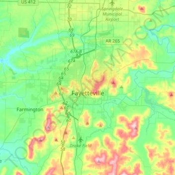
Nombre: Mapa topográfico Fayetteville, altitud, relieve.
Lugar: Fayetteville, Washington County, Arkansas, United States (35.98936 -94.29778 36.14893 -94.02671)
Altitud media: 401 m
Altitud mínima: 325 m
Altitud máxima: 581 m
...yet I venture the assertion that nowhere in said country—or for that matter, in any part of the state—could be found a lovelier elevation, or a lovelier grove of graceful oaks, or a more commanding view, or, in fine, a spot better suited and adapted for the purposes designated than the one chosen for said University [of Arkansas] site and farm.
Otros mapas topográficos
Haga clic en un mapa para ver su topografía, su altitud y su relieve.
Prairie Grove
United States > Arkansas > Washington County
Prairie Grove, Washington County, Arkansas, 72753, United States
Altitud media: 356 m
Springdale
United States > Arkansas > Washington County > Springdale
Springdale, Washington County, Arkansas, 72764, United States
Altitud media: 388 m
Springdale
United States > Arkansas > Washington County
Springdale, Washington County, Arkansas, United States
Altitud media: 398 m