
Mapa topográfico Blencathra
Mapa interactivo
Haga clic en el mapa para ver la altitud.
Acerca de este mapa
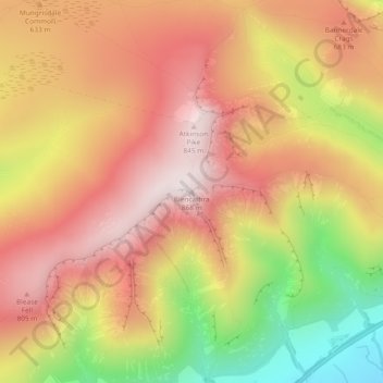
Nombre: Mapa topográfico Blencathra, altitud, relieve.
Altitud media: 577 m
Altitud mínima: 160 m
Altitud máxima: 854 m
The Northern Fells make up a roughly circular upland area about 10 miles (16 km) wide. At the centre is the marshy depression of Skiddaw Forest — a treeless plateau at an altitude of 1,300 ft (396 m.) — and flowing outward from here are the rivers which divide the area into three sectors. The southeastern sector, between the Glenderaterra Beck and the River Caldew, contains Blencathra and its satellites.
Otros mapas topográficos
Haga clic en un mapa para ver su topografía, su altitud y su relieve.
River Glenderamackin
United Kingdom > England > Westmorland and Furness > Threlkeld
River Glenderamackin, Threlkeld, Westmorland and Furness, England, United Kingdom
Altitud media: 346 m
Blease Fell
United Kingdom > England > Westmorland and Furness > Threlkeld
Blease Fell, Threlkeld, Westmorland and Furness, England, CA12 4SF, United Kingdom
Altitud media: 482 m
Wescoe
United Kingdom > England > Westmorland and Furness > Threlkeld
Wescoe, Threlkeld, Westmorland and Furness, England, CA12 4TB, United Kingdom
Altitud media: 279 m