
Mapa topográfico Willey
Mapa interactivo
Haga clic en el mapa para ver la altitud.
Acerca de este mapa
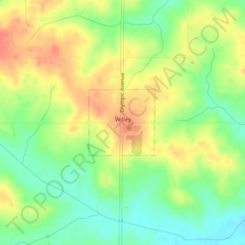
Nombre: Mapa topográfico Willey, altitud, relieve.
Lugar: Willey, Carroll County, Iowa, United States (41.97515 -94.82727 41.98243 -94.81750)
Altitud media: 390 m
Altitud mínima: 362 m
Altitud máxima: 417 m
Otros mapas topográficos
Haga clic en un mapa para ver su topografía, su altitud y su relieve.
Templeton
United States > Iowa > Carroll County
Templeton, Carroll County, Iowa, United States
Altitud media: 434 m
Middle Raccoon River
United States > Iowa > Carroll County > Carroll
Middle Raccoon River, Rolling Hills, Carroll, Carroll County, Iowa, 51401, United States
Altitud media: 385 m
Ralston
United States > Iowa > Carroll County > Ralston
Ralston, Carroll County, Iowa, 51459, United States
Altitud media: 342 m
Dedham
United States > Iowa > Carroll County
Dedham, Carroll County, Iowa, United States
Altitud media: 395 m
Manning
United States > Iowa > Carroll County
Manning, Carroll County, Iowa, United States
Altitud media: 415 m