
Mapa topográfico Speichersdorf
Mapa interactivo
Haga clic en el mapa para ver la altitud.
Acerca de este mapa
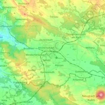
Nombre: Mapa topográfico Speichersdorf, altitud, relieve.
Lugar: Speichersdorf, Landkreis Bayreuth, Bayern, 95469, Deutschland (49.83482 11.70750 49.90259 11.86194)
Altitud media: 482 m
Altitud mínima: 395 m
Altitud máxima: 652 m
Otros mapas topográficos
Haga clic en un mapa para ver su topografía, su altitud y su relieve.
Warmensteinach
Deutschland > Bayern > Landkreis Bayreuth
Warmensteinach, Landkreis Bayreuth, Bayern, 95485, Deutschland
Altitud media: 738 m
Glashütten
Deutschland > Bayern > Landkreis Bayreuth
Glashütten, Mistelgau (VGem), Landkreis Bayreuth, Bayern, 95496, Deutschland
Altitud media: 468 m
Mehlmeisel
Deutschland > Bayern > Landkreis Bayreuth
Mehlmeisel, Landkreis Bayreuth, Bayern, 95694, Deutschland
Altitud media: 670 m
Pottenstein
Deutschland > Bayern > Landkreis Bayreuth
Pottenstein, Landkreis Bayreuth, Bayern, 91278, Deutschland
Altitud media: 471 m
Veldensteiner Forst
Deutschland > Bayern > Landkreis Bayreuth
Veldensteiner Forst, Landkreis Bayreuth, Bayern, Deutschland
Altitud media: 450 m
Bad Berneck im Fichtelgebirge
Deutschland > Bayern > Landkreis Bayreuth
Bad Berneck im Fichtelgebirge, Landkreis Bayreuth, Bayern, 95460, Deutschland
Altitud media: 521 m
Goldkronach
Deutschland > Bayern > Landkreis Bayreuth
Goldkronach, Landkreis Bayreuth, Bayern, 95497, Deutschland
Altitud media: 527 m
Aufseß
Deutschland > Bayern > Landkreis Bayreuth > Aufseß
Aufseß, Hollfeld (VGem), Landkreis Bayreuth, Bayern, 91347, Deutschland
Altitud media: 445 m